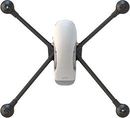
High-performance Geoscan Gemini for aerial surveys ensures the accuracy down to 5 cm.

Down to 5 cm horizontal accuracy

Up to 40 min
flight time

Survey up to 150 ha per flight with a GSD
of 3 cm/px

20.1 MP
camera
with APS-C
image sensor

Up to 30 km flight distance

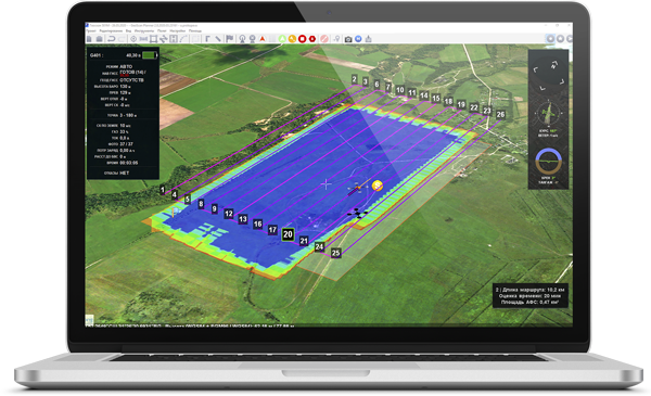
Geoscan
Planner
APPLICATIONS

CADASTRAL SURVEY

MAPPING

MINING
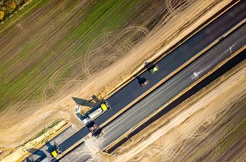
ROAD FACILITIES
Geoscan Gemini provides aerial photography with high-precision spatial data.
Map outputs:
- 3D point cloud
- Digital surface and terrain model (DSM, DTM)
- Orthomosaic map
- 3D textured polygonal model of surveyed area objects
Gemini covers up to 150 ha per flight with a GSD of 3 cm/px using route optimization and the algorithm for maintaining maximum limit speed depending on wind load.

Flight time
up to 40 min

Flight distance
up to 30 km
А built-in high-accuracy GNSS receiver can operate with GPS/GLONASS systems at L1/L2 frequencies. It allows achieving 1.5* cm accuracy of projection centers coordinates using PPK /PPP methods even with long baselines.
*actual accuracy depends on baseline length and measurement conditions (ionosphere, troposphere, visible satellites geometry, and multipath effect).
Coordinates accuracy
up to 1.5 cm
Gemini guarantees the best image quality with a 20-megapixel APS-C image sensor. Sony UMC-R10C can take high-quality pictures with less noise and higher dynamic range, even in low light conditions for obtaining more flight hours per day.
Each camera is precisely calibrated.

Flight mission management
in Geoscan Planner
Safety checklist before
takeoff
Flight task execution
Geotagging photos and
images
Calculation of accurate
projection center coordinates and photogrammetric plotting
Automated aerial photography process
Simply select the area and set parameters needed to start an aerial survey. The flight plan will be loaded to autopilot, and you need only to confirm the launch. Gemini will perform the mission with the specified altitude and images overlap. Captured images are automatically saved in on board SD memory card.
Manage your flight mission in Geoscan Planner for surveying areal and linear objects, using various flight modes (by points, based on terrain, etc.). Import kml and kmz files, use different cartographic bases, control the flight, and adjust the mission while working with the drone. After the flight is completed, the software creates a RINEX-file with the timestamps of photo moments.
Features:
- 3D framework for creating terrain-oriented flight tasks
- User’s maps and bases import (wms, wmts, tiff, kmz, tls)
- Automatiс flight task construction according to kml-files
- Camera setup
- Multiple coordinate systems
- Distant manual operating
- Playback mode
Reliable operation

No-magnet-compass routing algorithm provides fail-safe flight in magnetic anomaly conditions, which widens drone’s capabilities.


Specifications
| Aerial vehicle type | multirotor |
| Motors | electric brushless motors, 4 PCs |
| Weight (battery & propellers included) | 1.9 kg |
| Diagonal size (excluding propellers) | 550 mm |
| Max. flight time | 40 min |
| Max. flight speed | vertical 18 km/h horizontal 54 km/h |
| Max. flight altitude (ASL) | 4000 m |
| Max. flight altitude (AGL) | 500 m |
| Max. wind resistance | 10 m/s |
| Operating temperature | -15 to 40 °С |
| Max. resolution | 5456 × 3632 (20.1 MP) |
| Sensor size | APS-C (23.2 × 15.4 mm) |
| Shutter type | mechanical, shutter speed, focal-plane |
| Focal length | 20 mm |
| Max. aperture | f/2,8 |
| ISO range | 100 – 16000 |
| Mechanical shutter speed | 1/4000 – 30 s |
| Camera center offset (relative to the phase center of the onboard GNSS antenna) |
Х: 0 м Y: -0,0721 м Z: 0,0953 м |
| Number of channels | 184 universal tracking channels |
| Acquisition time (hot/cold start) | <2/<25 sec |
| Signals tracked | GPS: L1/L2; GLONASS: L1/L2; Galileo:E1B/E1C/E5c; BeiDou: B1I/B2I |
Positioning accuracy (PPK ) ) |
horizontal: 10 mm + 1 ppm × baseline length vertical: 10 mm + 1 ppm × baseline length |
| Operating frequency | 867.75 – 872.25 MHz |
| Transmitting power | <100 mW |
| Max. bandwidth | 500 kb/s |
| Max. delay | 20 ms |
| Duplexing mode | TDD |
| Max. range | 5 km |
| Battery type | Li-Ion |
| Voltage | 21.6 V |
| Weight | 710 g |
| Capacity | 6700 mAh |
| Energy | 144.7 Wh |
| Operating temperature | -15 to 40 °С |
| Input voltage | ~100 – 240 V |
| Input current | 1 A |
| Max. charge current | 6 A |
| Max. discharge current | 120 mA |
| Charging time (95% level) | 75 min |
| Charging time (100% level) | 105 min |
| Operating temperatures | 0 to 40 °С |
| Dimensions | 63×50×31 sm |
| Weight (including all parts of the system) | 12.6 kg |
| Protection class | IP67 |
| Wheeled | yes |

Product design – Smirnov Design

Package contents:


Geoscan Gemini UAV
Battery charger
Radio modem
2 Flight Battery
Propellers, 6 pcs
32 Gb SD memory card
USB Type-C cable
Transport case