Geoscan copters

From the compact Gemini to the multifunctional Geoscan 401, capable of lifting both a camera and a magnetometer into the air, our industrial quadcopters are used in engineering and geodetic surveys, in modeling infrastructure facilities, certification of roads and railways, in planning detailed ground geophysical, mining and drilling operations, and etc. The onboard GNSS receiver provides five-centimeter accuracy and reduces the time spent on flight preparation and processing.
Fully automated systems

Fully automated systems

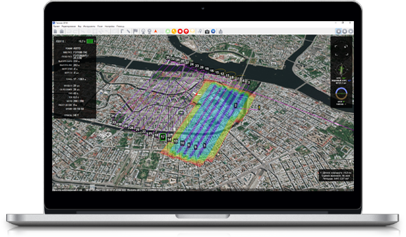
All Geoscan airplanes operate fully automatically. Just point out the survey area on an interactive map and the UAV will do the rest of the job..

The launch is executed by placing the UAV on the catapult and pressing the button on the ground control station. At the end of mission UAV will smoothly parachute down to the launch point. Our smart autopilot is designed for fail-safe operation even in severe conditions and is equipped with a set of sensors for continuous flight parameters monitoring: air speed, altitude, attitude and battery level.

In a case of any emergency situation UAV will automatically fly back to the launch point or perform an emergency landing. Managing the flight from the ground station, you can always cancel or change the mission in a few clicks.

Geoscan Gemini

Gemini is a new generation aerial photography system that combines technology and high performance. The quadcopter allows you to achieve the planned accuracy of the photogrammetric model of 5 cm.

Geoscan 401 Geodesy

The complex is designed to automatically perform aerial photography and process images and georeference data (flight telemetry and ground control points). Based on them, a textured 3D terrain model, a DEM and an orthomosaic of various scales, including 1:2000 and 1:500, are created.

Geoscan 401 Tethered

The unmanned system is capable of staying in the air for 72 hours, providing continuous video surveillance of the area in the optical and infrared ranges or relaying communication channels. Can be used with payloads weighing up to 2.5 kg and power consumption up to 50 W.

Geoscan 401 Geophysics

The aeromagnetic complex allows you to perform high-precision aeromagnetic surveys at extremely low altitudes both in flat terrain and in difficult landscape conditions with detailed contouring of the relief.

Geoscan 401 Lidar

Designed for laser scanning and subsequent construction of three-dimensional models of terrain or individual objects. An AGM laser scanner with a built-in GNSS receiver is installed on the UAS as a payload.

Geoscan 401 Gamma

Designed to perform gamma spectrometric surveys and build on its basis maps of potassium, uranium and thorium content, secondary radiogeochemical zoning and exposure dose rate. The GS-1 gamma spectrometer is installed on the UAS as a payload.

Geoscan Pioneer

Go to series
Multifunctional educational and methodological complex for schools, aircraft modeling sections, robotics clubs and self-study.
x
Product comparison
 Show: main difference characteristics equipment  clear list

ProductLoading...
The list of comparisons is empty.
 
Close comparison
  Product comparison