Advantages of Geoscan UAV technologies for Mining industry
Upon surface mining operation, availability of accurate and relevant geometrical data about surface of the open pit, open cast or mine is the key condition for successful solution of surveying issues. Surface survey methods require much time for filed works performance. Office works on the development and updating of the mapping documents are exposed to the human factor impact. This results in distortion of terrain mapping and, finally, reduces accuracy and quality of the surveying works.
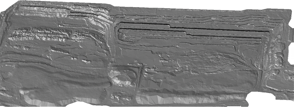
High-res 3D model of an open coal mine.
Digital terrain models obtained with the help of Geoscan technologies are much more detailed than the models developed according to the ground surveys. They are made in the form of a regular grid with the centimeter spatial resolution. UAV application is much more cost effective and rapid than the surface methods. In regard to the accuracy, its results are close the aerial laser scanning results. Monitoring of the open pits and open casts with the use of Geoscan technologies allows to improve safety and effectiveness of works, increases their accuracy while reducing costs and labor efforts.
Orthophotomaps, terrain models and point clouds
With the help of our UAVs, you can perform survey of the objects rapidly and as frequently as required. Exclusive quality and high accuracy of the obtained geospatial data allows to develop and keep updated mining-graphic documentation. You can develop digital topographic maps with different scales, build 3D terrain models, section and profiles, create supplementary schemes, as-built drawings and visual presentation materials.
Calculations, measurements and design
Analyze condition of the sides and create terrain profiles with the help of highly precise digital models of the area. Detect deformations and displacements according to the results of the regular surveys. Determine scope of the mining operations with the accuracy of laser scanning due to the dense cloud of points. Increase effectiveness of mining operations designing by using advantages of the metrical photorealistic 3D models.
Monitoring of the open pits and productivity enhancement
Geoscan aerial survey technologies will allow you to assess impact on the environment, manage property and equipment. Accuracy and completeness of the obtained information will allow to reduce operational risks and will provide assistance upon making process and managerial decisions. Possibility of online data transmission enables to carry out visual control of remote objects at all stages of works.