- Geoscan 3U Platform Based Small satellites
- InnoSat16 Small satellites
- Geoscan’s Cleanroom: Where Satellites Are Assembled
- Plans for the Development of the Geoscan SSC Constellation
- Upcoming Stages of Geoscan Small satellites Launches
On July 25, 2025, at 08:54 Moscow time, a Soyuz-2.1b launch vehicle with a Fregat upper stage lifted off from the Vostochny Cosmodrome as part of the Ionosphere-M Mission Nos. 3 and 4 under the program of the State Corporation Roscosmos. In addition to the main payload, the rocket deployed into orbit 18 small spacecraft, including nine experimental satellites developed by Geoscan Group, designed to test communication and Earth remote sensing (ERS) technologies. All satellites were launched into a sun-synchronous orbit at an altitude of approximately 500 km, housed in launch containers provided by the Russian company Aerospace Capital as part of the rideshare payload. JSC Glavkosmos (a subsidiary of Roscosmos) served as the primary integrator for the launch of additional spacecraft and provided the launch services.
The mission successfully placed eight satellites based on the Geoscan 3U platform and the first Russian CubeSat in the 16U form factor — InnoSat16 — into orbit. Two satellites, InnoSat3 and InnoSat16, are part of a project implemented under a grant program aimed at supporting the “scaling up” of corporate suppliers. The program is operated by the Center for Engineering and Innovation Support.
“This satellite constellation is the result of several years of systematic work by Geoscan’s space division. Such launches not only allow us to test new technologies and expand partnerships but also to tackle research objectives that go beyond the framework of educational programs. CubeSats in the 3U and 16U form factors are compact and relatively low-cost spacecraft, suitable for universities as well as for efficiently testing cutting-edge domestic technologies in communications and Earth remote sensing. The experience gained will be invaluable for implementing larger-scale space initiatives — for example, missions into lunar orbit,” said Alexander Khokhlov, Head of the Small Spacecraft Projects Department at Geoscan Group.
Geoscan 3U Platform Based Small satellites
Satellites built on the Geoscan 3U are designed to carry out a range of research and technology demonstration tasks.
Geoscan-1 is equipped with two Cyclop survey cameras — one with a Long-focus lens and one with an ultra-wide-angle lens — capable of capturing images at resolutions up to 3 megapixels and recording video at 30 frames per second. Images of Earth taken from the satellite will be transmitted in the amateur radio frequency band.
Geoscan-2 is designed to test Automatic Dependent Surveillance–Broadcast (ADS-B) technology, which enables tracking aircraft position, velocity, and direction. The satellite will assess the feasibility of using ADS-B on small spacecraft to monitor unmanned aerial vehicles (UAVs) within Earth’s atmosphere.
Geoscan-3 focuses on testing VHF-band communications.
Geoscan-4 and Geoscan-5 carry transceivers developed by JSC “Gonets Satellite System” (part of Roscosmos). These satellites will test packet data transmission technology, used in remote monitoring, personal communications, and Internet of Things (IoT) applications.
Geoscan-6 carries two Cyclop cameras and a gamma spectrometer, jointly developed by Geoscan Group and the Ioffe Physical-Technical Institute of the Russian Academy of Sciences. The images captured by the cameras will be transmitted to Earth in the amateur radio band, while data from the gamma spectrometer will help localize gamma-ray bursts and provide insights into various cosmic processes.
InnoSat-3 is designed to test an Automatic Identification System (AIS) receiver. AIS technology enables tracking of maritime vessels — their position, speed, and heading — which helps prevent collisions. Satellites equipped with AIS relay this data to relevant authorities, monitor ships in open waters, and support the development of specialized commercial services.

239Alferov was developed for the Space-π program under the Innovation Promotion Foundation, commissioned by Presidential Physics and Mathematics Lyceum No. 239 and the Zhores Alferov Physics and Technology School. It carries a gamma spectrometer (a joint development of Geoscan Group and the A. F. Ioffe Institute) and a VERA plasma thruster designed by the National Research Nuclear University MEPhI. The VERA engine will be used to test orbital maneuvering capabilities on small CubeSats. The onboard computer of 239Alferov also contains 7,787 names and over 3,500 images submitted by participants of the Send Your Name to Space campaign. The 67 most remarkable drawings will be broadcast in the amateur radio band at 436.27 MHz under the callsign RS61S.
All of these CubeSats are equipped with next-generation GNSS antenna boards developed by Geoscan Group to improve the reception of signals from global navigation satellite systems.
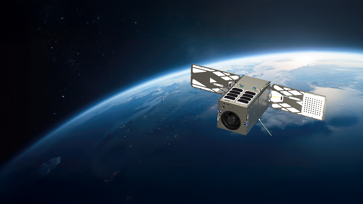
InnoSat16 Small satellites
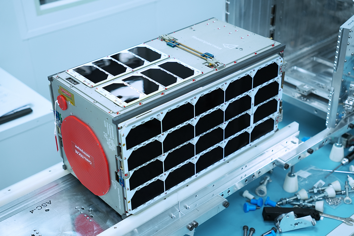
InnoSat16, based on the Geoscan 16U platform, is the first Russian CubeSat of this form factor to be launched into orbit. Its deployment opens up new opportunities for Geoscan in the field of space-based Earth remote sensing (ERS). The satellite’s testing and operation mark the first step toward creating a dedicated constellation of small remote-sensing spacecraft.
Let’s take a closer look at the key features of InnoSat16.
The satellite carries a domestically developed panchromatic remote-sensing camera designed for imaging Earth’s surface.
Its key technical specifications are as follows:
- single spectral band within the 0.53–0.8 µm range;
- nadir pixel projection: 2.5 m (at 500 km altitude);
- ground resolution: 4 m (at 500 km altitude);
- swath width at nadir: 12 km;
- lens (f/D): 1100/130 mm, with a 1.8° field of view.
The camera captures grayscale imagery with an extended visible spectrum and producing detailed images.
InnoSat16 features one of the most advanced attitude determination and control systems (ADCS) among CubeSats, combining high-precision algorithms with in-house–developed reaction wheels for attitude control. Its attitude and navigation system includes a star tracker, a three-axis fiber-optic gyroscope, three-axis magnetometers, solar sensors, a GNSS receiver with antenna, and a technical camera. The star tracker provides an attitude accuracy of 10–70 arcseconds.
The satellite is powered by deployable, radiation-resistant solar panels featuring gallium arsenide (GaAs) photovoltaic converters, along with a redundant power supply system uninterruptible. The system features redundancy of critical subsystems and batteries for increased reliability.
A narrowband VHF radio link has been developed for command interface and telemetry. Payload data is transmitted via a broadband downlink using a high-speed X-band transmitter. InnoSat16 will enable Geoscan Group to validate technologies for rapid and efficient receiving of high-quality remote-sensing data from small spacecraft.
An equally important milestone is that InnoSat16 was integrated with the 16U deployers developed by Aerospace Capital for its deployment — making it the first Russian satellite to be placed in orbit using a 16U-format Aerospace Capital container.
The Small satellites separation system consists of a cubesat deployer and an electronics control unit. The container provides mechanical and electrical adaptation of the spacecraft to the launch vehicle. Once the target orbit is reached, the electronics unit sends sequential commands to open each door, deploying the satellites via spring mechanisms.
For this mission, the Aerospace Capital engineering team enhanced the separation system. Improvements included redesigning the deployer doors: whereas both doors were previously equipped with magnetic locks, the updated version activates only one. This change reduced the container’s weight by 1.2 kg and decreased the number of actuators. The modification also allows a single control unit to manage multiple containers, improving mission efficiency for payload deployment. The updated 16U container is 11.5 cm taller than the 12U version, yet retains identical key mechanisms already proven during flight tests with 12U CubeSat containers.
In addition, eight Geoscan 3U Small satellites launched on this mission were integrated using two Aerospace Capital 12U containers (4×3U).
“Together with Aerospace Capital, we have successfully Launched fifteen 3U CubeSats and the first 16U CubeSat in Russia into orbit. We are continuing joint work on more complex platforms. This collaboration is a vivid example of how Russian private space companies can cooperate effectively. By integrating our technologies, we can rapidly develop new satellite constellations,” said Alexander Khokhlov, Head of Small Spacecraft Projects at Geoscan.
“The main priority of Aerospace Capital is ensuring spacecraft safety — from integration in our laboratory to final separation in orbit. Geoscan is actively expanding its space program, and we continue improving our deployment systems to provide partners with efficient, reliable solutions for microsatellite integration, launch, and in-orbit release,” added Valeria Barashkova, Sales and Marketing Director at Aerospace Capital.
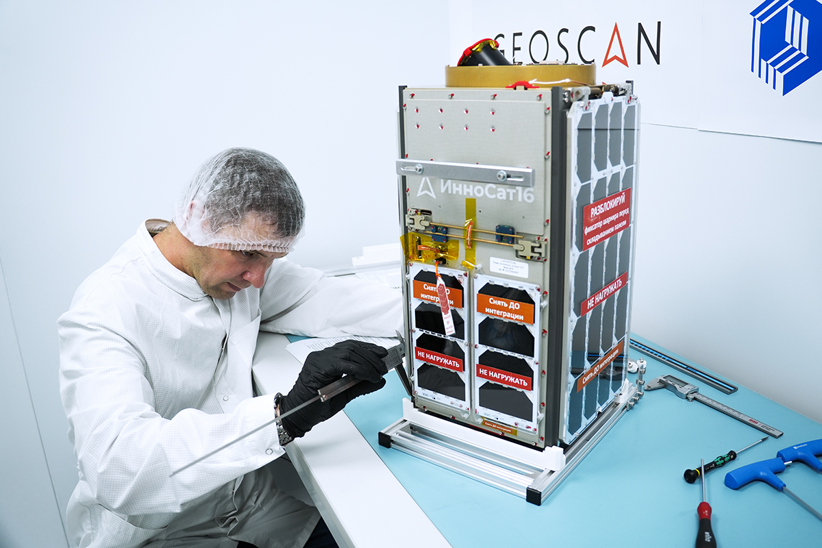
Geoscan’s Cleanroom: Where Satellites Are Assembled
To assemble InnoSat16, Geoscan Group established a dedicated cleanroom — a specialized facility with precisely controlled environmental parameters. It is designed for performing technological operations that require a minimal level of air contamination. The cleanroom occupies an area of about 30 m2 and meets the ISO 7 cleanliness standard according to GOST R ISO 14644-1–2017.
The cleanroom is constructed based on the zonal principle and includes three main functional areas. The first is an anteroom-transition zone, which is intended for staff to change into special clean clothing. Behind it is an air shower, where any possible contamination is removed from the surfaces of suits and equipment with purified air.
The primary working area is used for the assembly of spacecraft. It is equipped with antistatic flooring and technological equipment for working with high-precision optics and electronics. The ventilation and climate control system ensures multiple air recirculation through HEPA filters, maintains stable temperature and humidity parameters, and creates positive pressure to prevent external contaminants from entering.
After the launch of InnoSat16, the cleanroom is utilized for preparing subsequent space missions. Currently, the second 16U CubeSat called “Lobachevsky” is assembled there, developed by Geoscan for Lobachevsky State University of Nizhny Novgorod under the Space-π project. Hyper- and multispectral cameras are installed on the spacecraft, requiring special assembly conditions. The launch of Lobachevsky into space is scheduled for late 2025.
“The creation of a cleanroom has become a crucial milestone in the development of Geoscan's space initiative. This not only expanded our research and production capabilities, but also enabled the initiation of large-scale projects in the fields of space communications and Earth remote sensing. The plans include expanding the cleanroom area to achieve the goal of preparing small spacecraft-based interplanetary missions for creating detailed 3D models of the Moon and Mars,” noted Vladimir Portnov, head of experimental production at Geoscan.
Plans for the Development of the Geoscan SSC Constellation
At the first stage, Geoscan plans to launch six 16U CubeSats to form an Earth remote sensing constellation in orbit. At the second stage, the company intends to conduct experiments with 60U-platform satellites, which will provide higher spatial resolution.
The microsatellite constellation will be designed to address the following objectives:
- contributing to the national spatial data system;
- monitoring land and territorial conditions;
- monitoring agricultural areas;
- conducting forest inventory;
- monitoring construction sites and other activities.
“A large number of remote-sensing satellites are not necessary for operations within Russia. Of course, there’s the example of the American company Planet, which has launched hundreds of CubeSats and images the entire land surface daily. However, even considering Russia’s vast territory, it is still several times smaller than the world’s total land area — so daily imaging isn’t needed at this stage. Based on our estimates, six CubeSats with a 2-meter-per-pixel resolution will be sufficient. We also plan to develop several higher-resolution satellites: two with a 1-meter-per-pixel resolution, and one with a 50-centimeter-per-pixel resolution for imaging cities and large construction projects. We will expand the constellation only if these satellites are unable to meet demand,” explained Alexey Semenov, Chairman of the Board of Directors of Geoscan Group.
Upcoming Stages of Geoscan Small satellites Launches
| Stage One | Stage Two | |
| Satellite readiness | 2025–2026 | 2026–2027 |
| Orbit altitude | 375 km | |
| Pixel projection at nadir | 1,9 m | 0,9 m |
| Spectral channels | 4 | 1/4 |
| Swath width at nadir | 12,2 km | 11,7 km |
| Satellite mass | 30 kg | 120 kg |
| Period of active service | 5 years | |
| Number of satellites | 6 | 2 |
Article authors: Geoscan press service.
Published in the Geoprofi Journal No. 4, 2025.