Geoscan 401 Geophysics


Geoscan 401 Geophysics
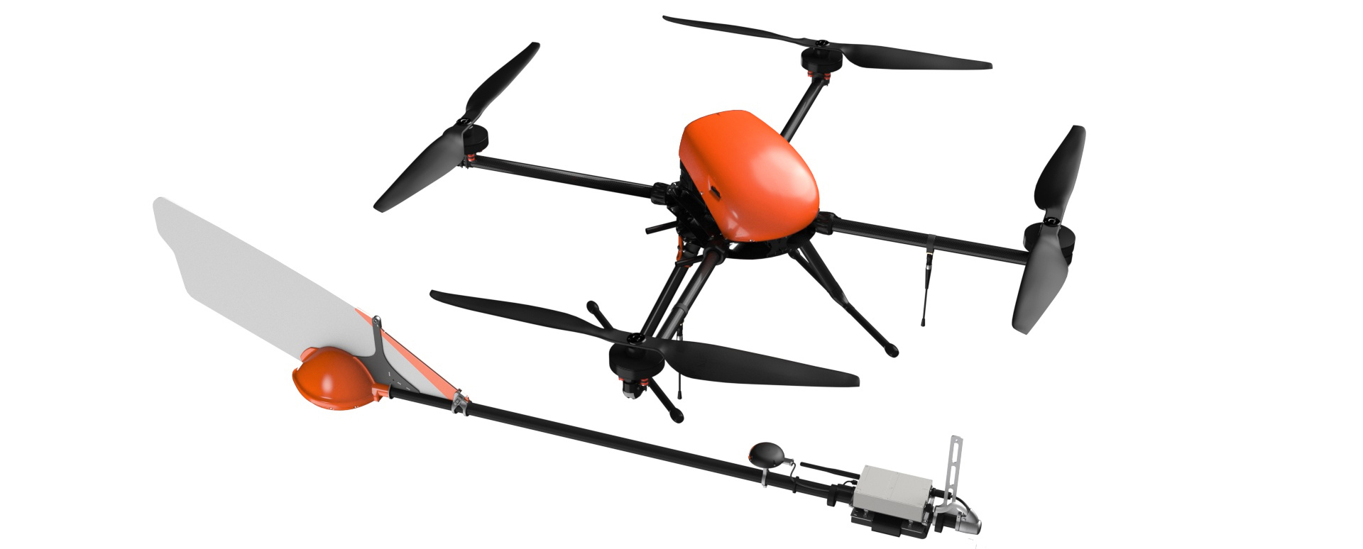
Complex with a quantum magnetometer for an aeromagnetic survey.


Unique unmanned system for aeromagnetic surveying with quantum magnetometer.
Overview
The Geoscan 401 Geophysics aeromagnetic system combines the benefits of the Geoscan 401 industrial quadcopter and a quantum magnetometer with a rubidium magnetic field sensor.
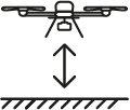
This UAV system allows operation at a low altitude both in flat terrain and in a more complex landscape.
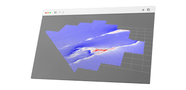
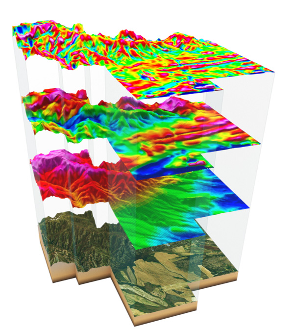
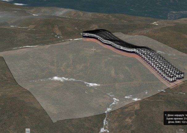
With the Geoscan 401 Geophysics system you can measure a magnetic field using a multi-elevation survey. New data analysis method allows creating a high level of fidelity for geomagnetic models.
UAV survey method is most useful for mid-sized areas from 10 to 500 km2. At this point, this method is financially viable if compared with manned aviation (planes, helicopters) and saves time on the survey.
Instructions:

Technology overview

Unmanned magnetic survey
with aerial drone
- Automatic flight mode
- Proximity flight with close-to-the-ground maneuvering
- Zero own magnetic field affection
Automatic
data visualization
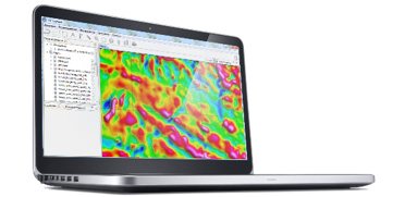
- Data georeferencing and interpolation to a three-dimensional uniform grid
- Field analysis of data
- Ability to split data into separate routes
Processing,
analysis and interpretation
- Accounting of data from magnetic variation stations
- Export to .geotiff file
Work stages
Method efficiency
- Maximum cruising speed of magnetic survey: 36 km/h.
- The minimum relative safe flying altitude depends on the landscape at the site, and maximum flying altitude can be as high as 4000 m above sea level.
- The duration of one flight (from takeoff to landing) is determined by the battery capacity of the UAV’s power supply and payload mass and is up to 45 minutes. During this time, aeromagnetic survey of 22 linear kilometers can be performed (including approach and departure).
- With regular battery replacement, up to 330 linear kilometers of survey routes can be completed in one survey day.
Max. flight route length
Up to 330 km in 1 day
Geoscan magnetometric system
Combines key advantages of autonomous UAV and quantum magnetometer with rubidium sensor. It can perform a precise aeromagnetic survey at extremely low altitudes in any terrain conditions due to proximity relief-follow flight.
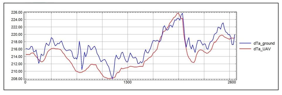
With Geoscan Geophysics system you can explore volumetric parameters of magnetic field. This is possible using altitude-differential survey and vertical profile calculation. New data analysis and interpretation methods allow creating geomagnetic models with breakthrough authenticity level.
Learn more about aeromagnetic survey
Key advantages
Less interference affection
On-foot survey is largely affected by surface interference, thus decreasing measurements accuracy.
Precise relief contouring
The system can perform precise aeromagnetic survey at extremely low altitudes in any terrain conditions due to proximity relief-contouring flight.

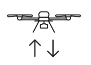
Multi-level magnetic measurements
Ensures highest level of precision when defining object's shape and position.


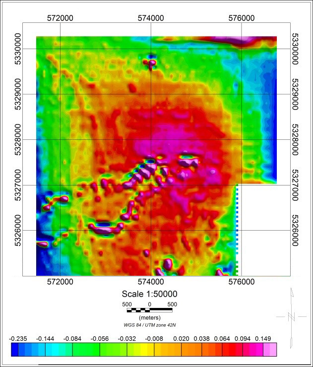
Data comparison
ММС-214 aviational magnetometer was used in 1988 to perform survey on the same site, where Geoscan 401 Geophysics system was applied in 2017. The results comparison is presented below:
Abnormal magnetic field
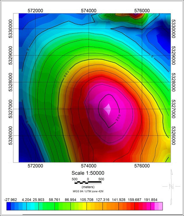
АН-2, ММС-214
Survey scale 1:25 000, 1988
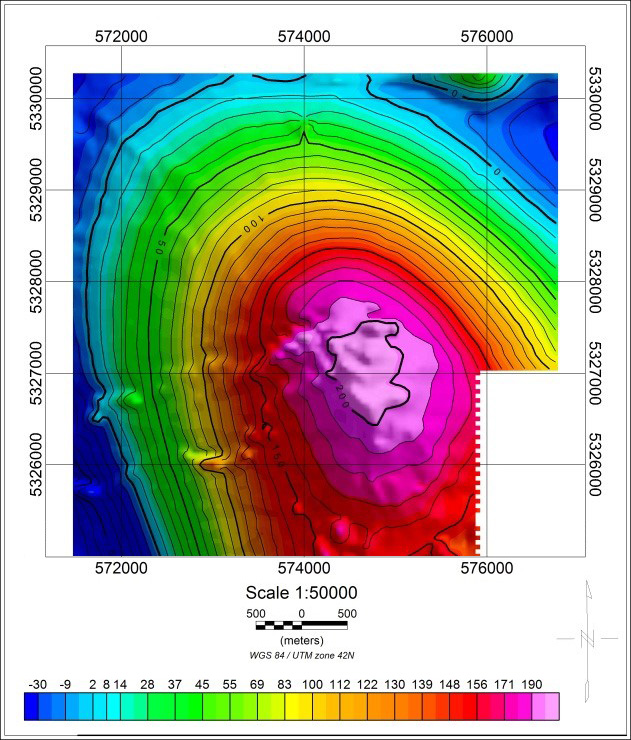
Geoscan 401 Geophysics
Survey scale 1:10 000, 2017
Magnetic field vertical gradient
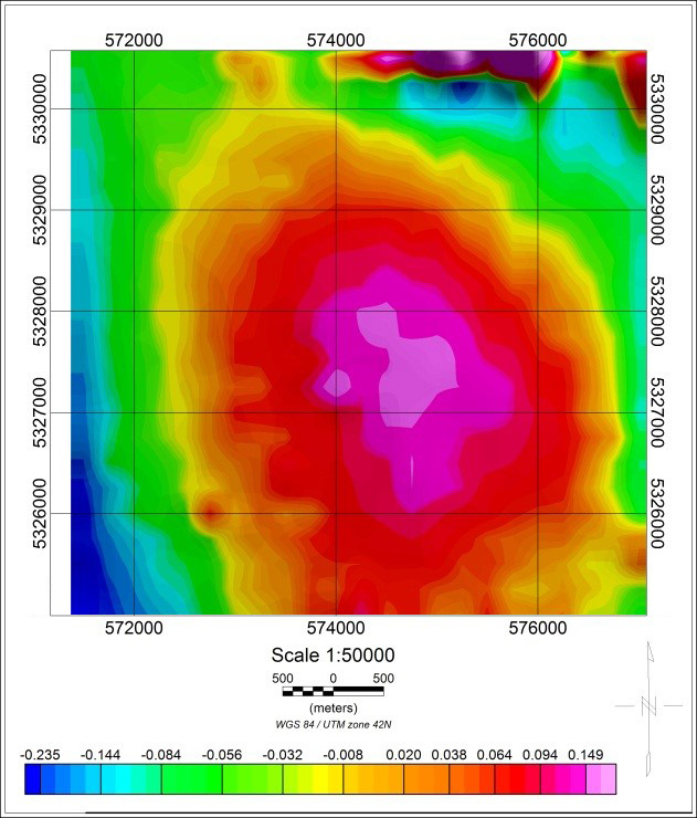
АН-2, ММС-214
Survey scale 1:25 000, 1988
Geoscan 401 Geophysics
Survey scale 1:10 000, 2017
Survey experience in Kazakhstan
Control without RC transmitter
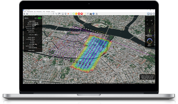
Geosсan Planner software allows to create flight missions for areal surveys of terrain and linear objects in different flight modes (point-by-point, areal survey, etc.). You can easily switch different base maps, upload your own maps, terrain models and photo plans to kml. or kmz. formats.
The software will automatically generate flight mission, send flightpath to UAV and track real-time flight status. All you need is to select the area on the map or upload your flightpath.
Main specifications
Flight time:
up to 45 min (with magnetometric equipment)
Max. route lengt:
22 km (per one flight)
Wind resistance:
12 m/s

Cruise speed:
up to 50 km/h
Dimensions:
While folded: 70х25х20 cm
Ready-to-flight: 150х150х43 cm
Min. safe flight altitude:
From 25 m
Max. flight altitude:
500 m
Operating temperatures:
from -20 to +40 °С
(optional expansion up to -40 °С is possible)
Motors:
electric, brushless
Take-off:
vertically, automatically, from platform 5x5
Magnetometer specifications
| Sensitivity | 1 pT/√HZ |
| Measurement range | 20000 nTl – 100000 nTl |
| General deviation error | < 0,3 nTl |
| Measurement frequency | 1000 Hz |
| Feedback loop bandwidth | 30 Hz |
| Sensor angle range | ± 45° |
| Operating temperature range | from – 20 to + 40 °С |
Basic package consist of :
- Unmanned aerial vehicle (UAV) Geoscan 401
- Two batteries with a protection system - 3 pc.
- Triple-system (GPS/GLONASS/BeiDou) GNSS receiver with dual band (L1/L2) antenna
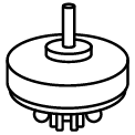
- Geoscan Geoscan GeoShark quantum magnetometer
- Spares and accessories kit
- Flight management(or ground control station) software : Geoscan Planner
- Radio link modem
- Charger in transport container (size: 51x41x22, weight without batteries: 7.3 kg)
- UAV transport container (IP67, size: 80x52x31 cm, gr.wt.: 16 kg)
- User's Manual
Operator Training in St. Petersburg
- Introduction to Geoscan UAV & workflow
- Flight planning & management with Geoscan Planner
- Practical work in the field
Extra
- Upgraded photogrammetric camera 45 MPix
- Metashape Professional software
- «Arctic» modification (extends temperature range to -40..+20 °С )
- Gamma-ray spectrometer GS-1
Additional software
Geoscan Planner
Mission planning software which makes precise relief contouring possible for Geoscan 401 Geophysics system.
Agisoft Metashape
Geospatial data processing software to create accurate digital terrain models.
Learn more about Metashape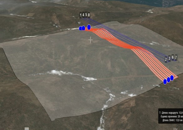

1 Year / 80 flights warranty

System operation training course
