• Company
  • Contacts
  • Blog
Products
All products
Fixed wing UAVs
Geoscan 701
Geoscan Lite
Geoscan 201
Copters
Geoscan Gemini
Geoscan 401 Geophysics
Geoscan 401 Geodesy
Geoscan 401 Tethered
Geoscan 401 Lidar
Geoscan 401 Gamma
Geoscan Pioneer
Geoscan Pioneer
Geoscan Pioneer Mini
Indoor navigation system
Compontents
Geoscan Pollux
Small satellites
Nanosatellites
Microsatellites
Services
All services
Aerial survey and 3D mapping services
Aeromagnetic survey
3D models of territories
Thermal imaging
Power transmission line inspection
Airborne laser scanning
More
Contacts
Blog
  • +7 812 363-33-87
  • Contact us
  • Technical support
Geoscan Geoscan
  • Products
    • Fixed wing UAVs
      • Geoscan 701
      • Geoscan 201 Geodesy
    • Copters
      • Geoscan Gemini
      • Geoscan 401 Geophysics
      • Geoscan 401 Geodesy
      • Geoscan 401 Lidar
      • Geoscan 401 Gamma
    • Geoscan Pioneer
      • Geoscan Pioneer
      • Geoscan Pioneer Mini
      • Geoscan Pioneer FPV
      • Indoor navigation system
      • Indoor IR-navigation system
      • Competition ground «Geoscan Arena»
      • Geoscan Pioneer Show
    • Components
      • Geoscan Pollux
    • Small satellites
      • Nanosatellites
      • Microsatellites
  • Services
    • Aerial survey and 3D mapping services
    • Aeromagnetic survey
    • 3D models of territories
    • Thermal imaging
    • Power transmission line inspection
    • Airborne laser scanning
  • Applications
  • Software
    • Agisoft
      • Metashape Professional
      • Metashape Standard
    • Sputnik
      • Sputnik GIS
      • Sputnik Agro
    • Geoscan Planner
  • Geophysics
  • Drone show
  • Technical support
  • 8 800 333-84-77
    info@geoscan.ru
  • Russian

Software

Home
Software
Geoscan

Geoscan Planner

Easy-to-use software for mission planning and controlling (including manual) as well as for video-monitoring and georeferencing of the data collected.

Geoscan

Metashape Standard

Freedom for creativity with photogrammetric image processing and 3D model generation software

Geoscan

Metashape Professional

Simple professional photogrammetry

Geoscan

Sputnik Agro

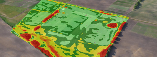
Geographic information system for precision agriculture.

Analyze state of crops, plan differential fertilization and land improvement activities based on the data of multispectral imagery and accurate information about the relief.

Geoscan

Sputnik GIS

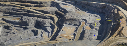
Professional drone surveying software for engineers, surveyors and urban planner.

Visualize and analyze multidimensional spatial data with no limits on data size, create surveys and get insights from your drone data in height performance GIS solution.

Приобрести продукт

Contact us for discussion and get free quote

Follow Us:


Companies

About

Projects

Blog

Partners

Products

All UAV

Buy UAV

Copters

Pioneer

Soft

Metashape Professional

Metashape Standard

GIS Sputnik

Sputnik Agro

Geoscan Planner

Contacts

+7 812 363-33-87

info@geoscan.ru

Telegram

Our offices

Technical support

FAQ

All information provided on the site is not a public offer

© 2025 Geoscan group of companies

Select spelling error with your mouse
and press ctrl + enter

Message sent

Thanks for the bug found!
We will fix it shortly.